fbpx

Hopton Castle – an aerial video.

with No Comments

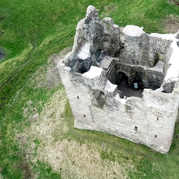
Drones, or UAVs are tools that can provide a lot of data, here we produced a small colourised height map of the immediate area for a castle ruin in Shopshire, as well as a short video. The impressive ruins of Hopton Castle lie to the west of the town of Craven Arms in South Shropshire. It was subject to a siege in 1644, and left in a state of ruin from at least the 18th century. However, in 2007, work … Read More

A video of Flounders Folly

with No Comments

A short video we produced from one of our drones, featuring Flounders Folly, a 19th century folly overlooking Corvedale. On top of Callow Hill, in South Shropshire, just to the East of Craven Arms, stands Flounders Folly. Built in 1838, it was restored in 2004. At 16 feet square, and 80 feet high, it is a landmark for miles around.After gaining permission from the Founders Folly Trust, we took the opportunity of a break in the freezing January weather to … Read More

Drone mapping of abandoned quarry workings

with No Comments

On Titterstone Clee Hill, just outside of Ludlow in Shropshire, there are some old, long abandoned quarry workings, ripe for an example of drone mapping. Using a Mavic pro drone, and Maps Made Easy, a pre-planned UAV flight was designed and flown. In all, 80 photos were taken and stitched together. The resulting images, once submitted to Maps Made Easy, were then used to generate a small 3D model of the area. The resulting images that were stitched together, are … Read More