fbpx

A quick multispectral drone survey of a field.

with No Comments

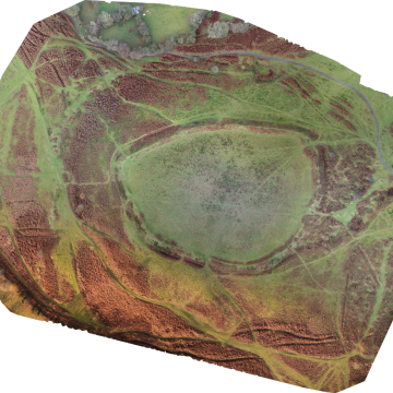
Agricultural imaging of a newly planted field by drone. On one of my walks during the Covid-19 ‘lockdown’ I happened across a field which had been planted during the previous winter. Several storms since it had been plated had done a huge amount of damage, washing what appeared to be a huge amount of soil, and crops out of the field, leaving it is a sorry state. I thought it would be ideal to use the field as a target … Read More

Drone mapping and modelling an Iron Age landscape.

with No Comments

Drone mapping within an Iron Age Settlement.   Maps. It has to be said, here at clearskyimaging we do love a good map or two! So much so that we have undertaken courses in mapping and photogrammetry with drones, and QGIS in order to present any mapping data we obtain for clients. Being based in Shropshire, within the Welsh marches, we do have a fair bit of history too.Here, we took the opportunity to investigate a local Iron Age hillfort, … Read More

A video of Flounders Folly

with No Comments

A short video we produced from one of our drones, featuring Flounders Folly, a 19th century folly overlooking Corvedale. On top of Callow Hill, in South Shropshire, just to the East of Craven Arms, stands Flounders Folly. Built in 1838, it was restored in 2004. At 16 feet square, and 80 feet high, it is a landmark for miles around.After gaining permission from the Founders Folly Trust, we took the opportunity of a break in the freezing January weather to … Read More