Drone mapping and modelling.

Up until very recently, the only way to get up to date mapping data was to use aircraft, small aeroplanes or helicopters. Satellite data, including that from Google or Bing is now available of course, but that isn’t always up to date, and, of more importantly, if it’s cloudy, then there’ll be no ground imagery at all. Drone mapping can change this.

The benefits of utilising drones / UAVs for mapping.

Mapping, from drones, or UAVs is changing the cost element of the traditional means of aerial mapping. The ability to create 2D and 3D models, often down to cm accuracy that can be of immense value to companies and organisations of all sizes. The upper height limit imposed by the Air Navigation Order of 400 feet, means that unless it is raining, snowing, or too windy, then drones can be used for mapping applications daily.

Here at Clear Sky Imaging, based in Shropshire, we have enhanced our knowledge and qualifications in using drones with additional training in mapping, photogrammetry and geographical Information Systems (GIS).

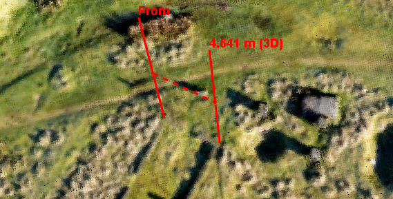
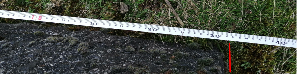
This enables us to understand the fundamentals of aerial imaging using drone based sensors for commercial usage. The end product is being able to produce enhanced mapping and processed geospatial data, presented using common GIS/Photogrammetry desktop applications. It also enables us to derive approximate measurements from pointcloud data acquired from our aerial platforms.

Common uses for the drone mapping data acquired are within construction, land surveying, real estate, insurance, quarrying, solar ‘farms’, wind power and agriculture.

drone mapping a golf course
Digital Elevation map of a par 3 golf course

Ortho and DEM images of a par 3 golf course from a drone. Superimposed on Google satellite view.

drone produced 3d model of a golf course

A 3D ‘model’ of the par 3 golf course generated from the above drone data.

Using drone /UAV operators trained in mapping and modelling techniques.

Lots of operators advertise drone mapping and modelling expertise, sadly, not all have undergone training to understand the fundamentals of the imaging that they can provide, which could mean that they struggle to provide the results needed. At ClearSkyImaging we understand the fundamentals, and can implement them to produce the desired Ground Sample Distance (GSD) that will enable measurements to be taken from orthophotos or pointclouds.

drone mapping of abandoned building in shropshire

Knowing the the relevant Field of View, height and GSD, skilled operators in drone mapping can utilise this knowledge to produce approximate measurements from the associated point cloud such as in this example of the base of a demolished building at an abandoned quarry.

Measurements taken with a 30m tape of the length and breadth of the remaining base of the walls show that the footprint of the demolished building is around 18.3m x 4.62m (Although being an old building, the walls are quite rough!)
Taking the measurements from the associated point cloud, the measurements can be seen to be quite accurate.

Measurements from a 3 ddrone mapping pointcloud
Measurement derived from drone mapping produced point cloud
18m measure
4m measure

As well as linear measurements, it is possible to do area, perimeter and volume measurements, the accuracy of both can be increased with the use of Ground Control Points (GCPs). GCPs and further processing will increase the time taken for the planning, flight and processing of the data.

If required, the data from any such work can be utilised to create a 3D ‘model of the area, including any buildings, and anything else of interest.

Most of this work will be completed utilising pre-planned flight plans that can be saved and re-run at intervals so that any maps or models can be viewed at intervals to see how any work is progressing.

Having undertaken training in Geographical Information Systems, we can, of course, also present any information in a format acceptable for clients’ use.


Volume measurement from a drone mapping exercise

3D modelling / Photogrammetry.

At Clear Sky Imaging, we have access to a variety of software solutions suitable for converting imagery from drone flights into 3D models.

We have, also, utilised ground based cameras, as well as pole cameras to produce 3D models where drones were unable to be used, due to permission issues, or the area being too close to trees or other structures to allow suitable imagery from our drones.

Some examples of both models produced from drones and ground based cameras are shown here:

We can help!

Clear Sky Imaging are based in the heart of the Welsh Marches, in South Shropshire. We look forward to being of help for any aerial mapping or photogrammetry needs for organisations and individuals in the surrounding areas, Herefordshire, Mid Wales, Worcestershire, Cheshire, Staffordshire as well as nationwide.
Please do get in touch, we’d be more than happy to discuss your needs!


Or, feel free to give us a call on (01584) 517070